Proposal for project :
MAKKARI 181
HDS intends to provide LiDAR drone and photogrammetric surveying and 3D mapping and modeling services for the project.
INTRODUCTION
Our understanding of the requirements are to perform 3D mapping and modeling services and produce a detailed survey report with associated digital file package, with analytics and information illustrating the deliverables described in the accompanied PDF.
SCOPE OF THE WORK
Our understanding of the requirements are to perform 3D mapping and modeling services and produce a detailed survey report with associated digital file package, with analytics and information illustrating the deliverables described in the accompanied PDF..
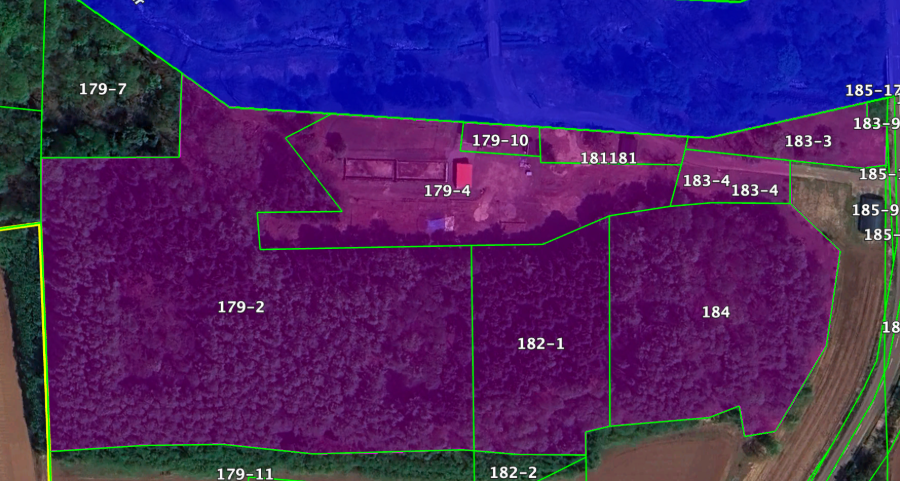
PLOTS
179-2, 179-4, 179-10, 181, 182-1, 183-3, 183-4, 184
IMPORTANT
Official deliverables are described in the accompanied PDF.
“Before anything else, preparation is the key to success.”
- Alexander Graham BellOur Process
-

Site Inspection and Planning
Together, we outline a path forward that’s realistic, strategic, and tailored to your specific needs.
-

Drone Flight and Operations
You’re part of the process. We keep communication open and decisions shared—no black boxes or surprises.
-

Data Processing and Analysis
Every project is different. We stay flexible and responsive to make sure the process fits your flow—not the other way around.
-

Report and Deliverables Preparation
When we deliver, it’s not just a finished product—it’s a solution you can trust, backed by real care and effort.
Project Timeline
The estimated time to complete the works is 34 days from the time the site is in adequate condition (free of snow/weather) to ensure accurate data collection, and ensure a clean orthomosaic map.
LET’S GET STARTED
Check out the details on the services and tasks we will carry out for your project.
Scrolling down the page, you can find some of the most significant analysis.
Our team is ready to provide the attention, care, and expertise you deserve.
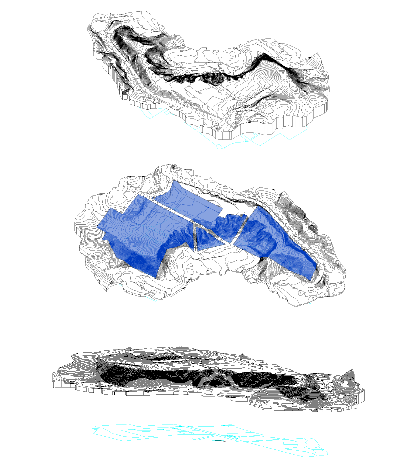
3D CONTOUR MODEL
Detailed 3D model of the site, context and wide area contour and terrain features, compatible with CAD software.
Perimeter boundary only and basic contour model only.
Pro pack will include each plot boundary, additional layers, and can be cut into parcels if the client envisages future subdivision, for supply to the end owner.
We’ll also produce an interactive viewer for assessment without specialised software.
3D SURFACE MODEL
Thanks to LiDAR capabilities we can generate two distinct 3D models:
The first represents the bare ground surface, accurately capturing terrain elevations and subtle topographic features after vegetation and structures are removed;
The second preserves the original scan with all elements on the ground—buildings, vegetation, infrastructure and other objects—allowing direct visualisation and measurement of the real-world scene.
Together these models enable precise analysis for tasks such as water management, civil works planning, asset position and change detection, by providing both a cleaned terrain reference and a full-context dataset for comparison.

HIGH PRECISION CAD FILES
Our CAD files for architecture and BIM are produced to exacting standards, delivering reliable geometry, consistent layer structure and precise metadata that enable professionals to integrate them directly into technical workflows.
The high level of accuracy ensures dependable measurements, clash-free model assembly and seamless interoperability with common BIM platforms, supporting tasks such as structural coordination, MEP planning, cost estimation and permit documentation.
Clear naming conventions and comprehensive attributes reduce time spent on CAD housekeeping, while adherence to industry standards facilitates collaboration across design, engineering and construction teams, accelerating property design and development with confidence.
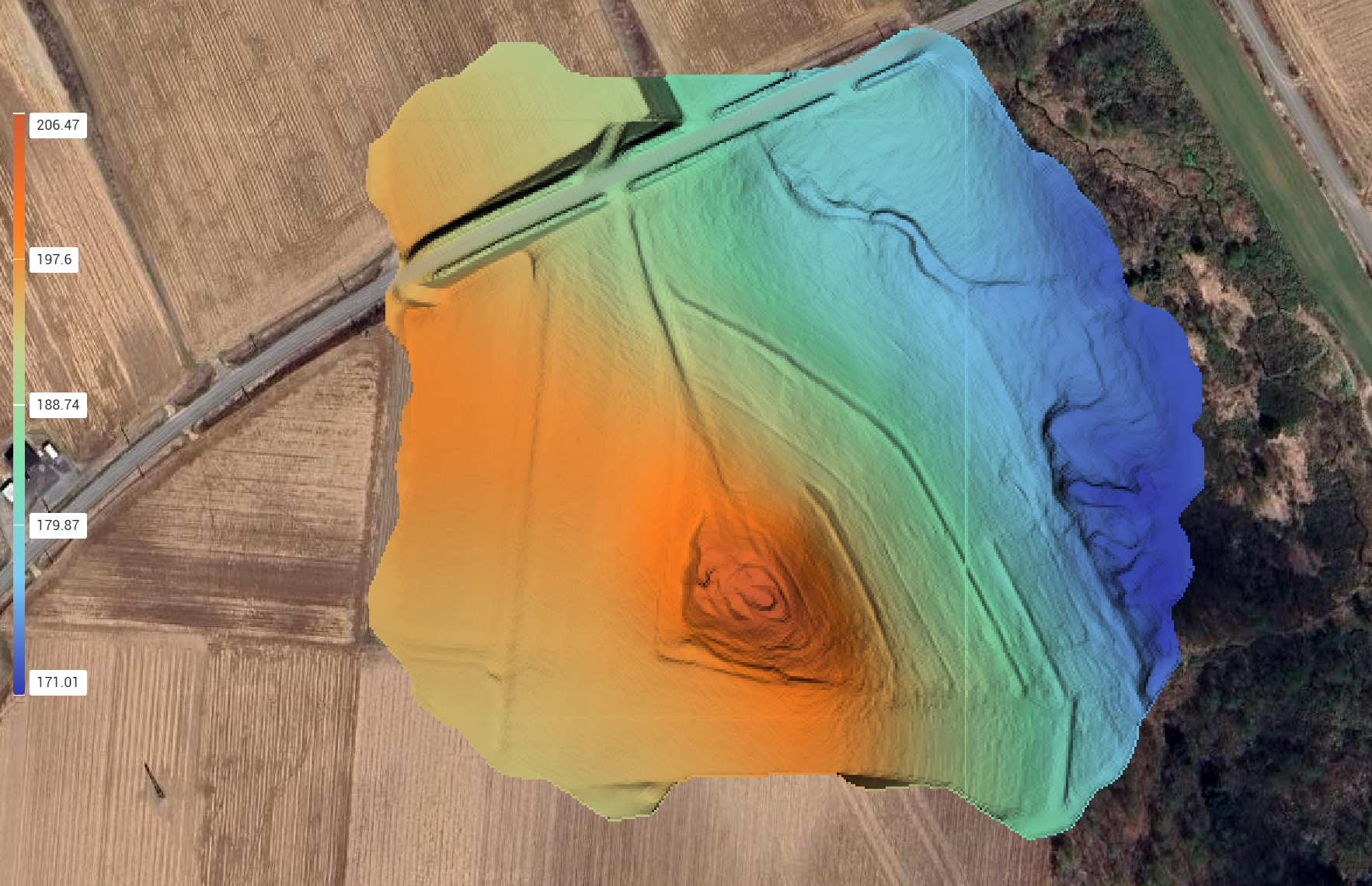
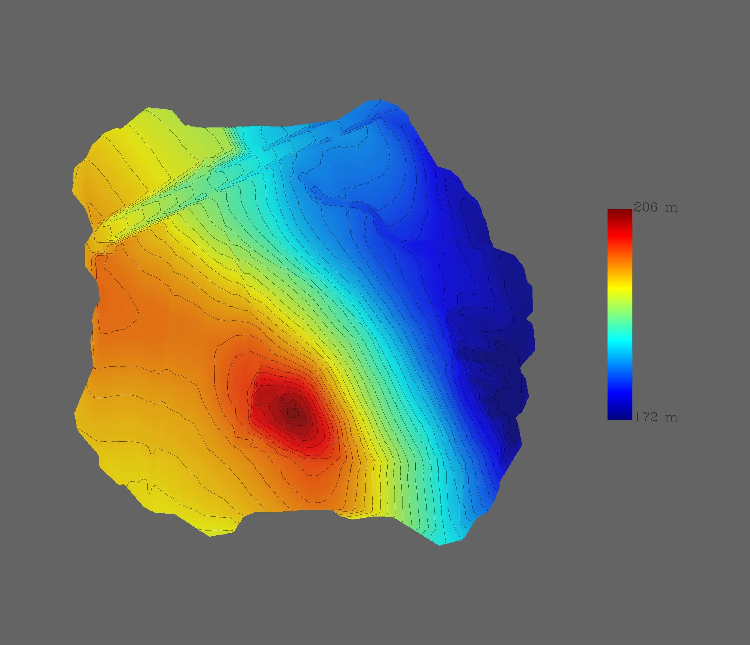
2D ELEVATIONS HEAT MAP
Multiple 2D elevation heat maps created using our drone technology and specialised software provide a clear, colour-coded representation of terrain variations, combining high-resolution aerial imagery with precise LiDAR and Photogrammetric Data to deliver accurate elevation contours and gradient information.
This allows engineers, planners and surveyors to quickly identify slopes, depressions and potential drainage issues, assess site suitability, and monitor changes over time with quantifiable metrics, all produced efficiently and safely from airborne surveys that minimise ground disturbance and reduce project timelines.
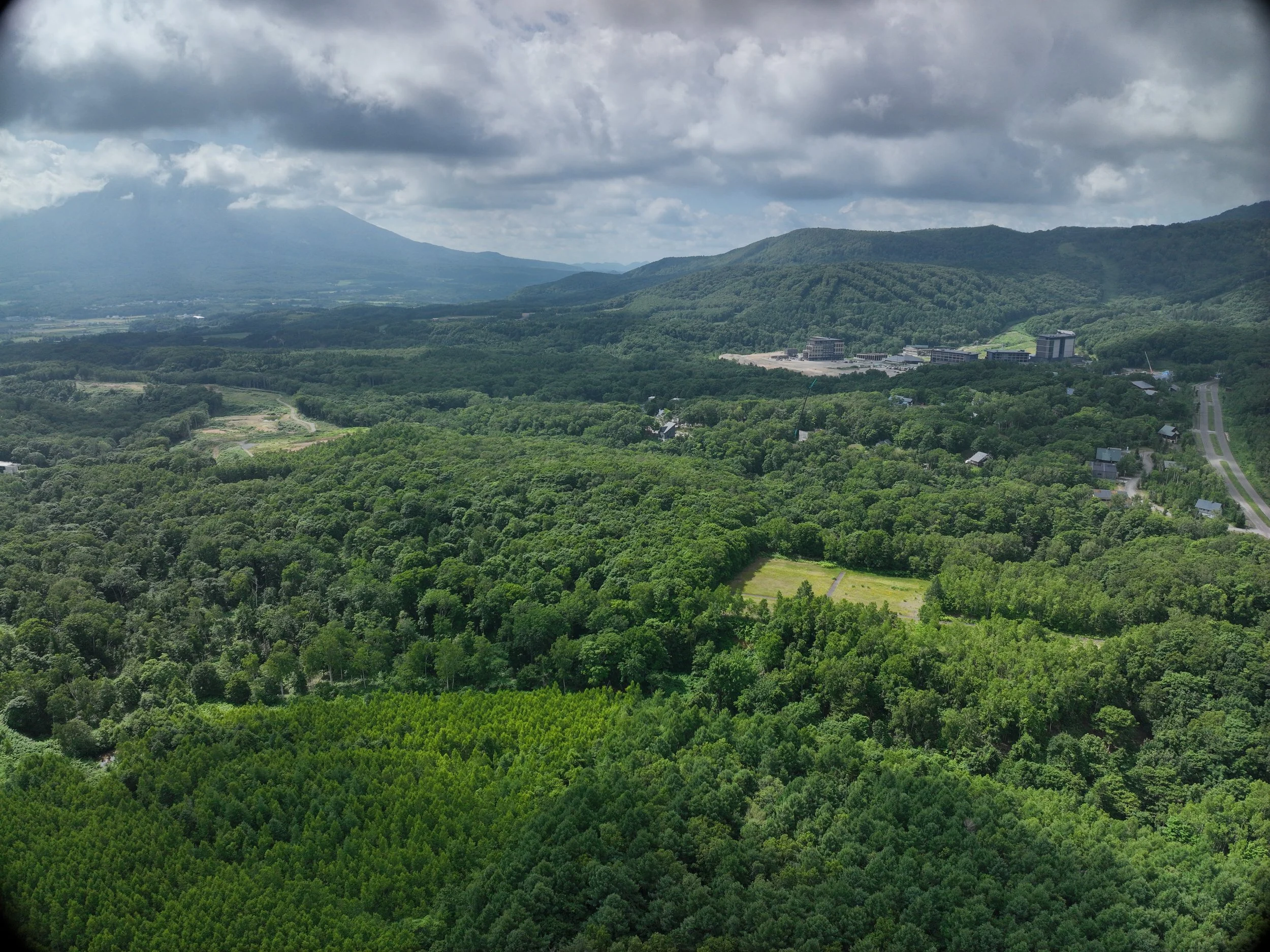
AERIAL IMAGES AND VIDEOS
Aerial footage adds an intriguing perspective to the real estate industry.
By providing a bird’s-eye view of expansive sites and buildings, it effectively conveys the appeal of a property.
It also clearly showcases surrounding environments, views, and advantageous locations, which are often difficult to grasp from the ground level, thereby attracting prospective buyers and leading to higher closing rates.
Aerial footage is not just a video; it is a powerful marketing tool that enhances the value of properties.
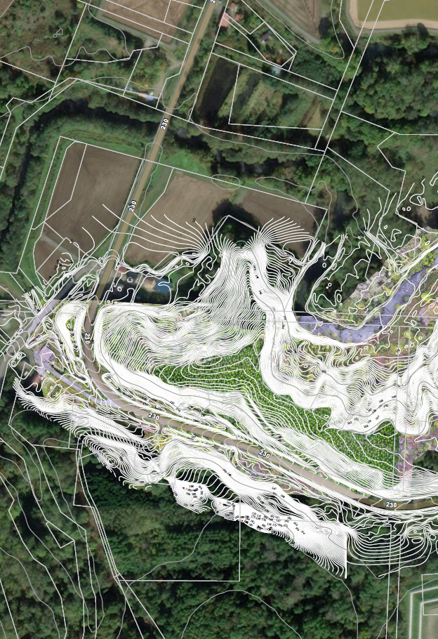
PARCEL PLAN
The Parcel Plan 2D map overlaid on contour data provides a precise, unified view of the property, combining parcel boundaries, access points and legal limits with detailed elevation and slope information.
This integrated presentation enables architects and developers to assess site constraints, drainage patterns and cut-and-fill requirements at a glance, inform placement of buildings and infrastructure, optimise orientation for sunlight and wind, and reduce design iterations by revealing potential issues—such as flood-prone low points or steep sections—early in the planning process, ultimately streamlining feasibility studies and accelerating informed decision-making for future projects.

INTERACTIVE REALISTIC DIGITAL MODEL
Premium Service
A next-generation 3D reconstruction that prioritizes visual realism over traditional geometric meshes.
Utilising Photogrammetry and Gaussian Splatting technology, we build an interactive, realistic digital model enabling the user to zoom, orbit and pan.
A less technical deliverable allowing the user to immerse into the site and assess terrain features and surrounds.
These models allow for highly detailed, realistic representations of buildings and environments, helping potential buyers and investors to better understand the spatial dynamics and aesthetic qualities of a property.
By leveraging Gaussian Splatting techniques, real estate professionals can create immersive and accurate 3D experiences that effectively communicate the value and potential of a space.
Use the mouse to
INTERACT
with this model.
Use the mouse to
INTERACT
with this model.
ORTHOMOSAIC
An Orthomosaic with contours is an indispensable tool in architecture and building planning, combining high-resolution, georeferenced aerial imagery with precise elevation data to produce an accurate, distortion-free map of a site and its topography.
Architects and planners use these composites to assess site conditions, design building footprints, model drainage and cut-and-fill volumes, and ensure compliance with slope and setback regulations, while the contour lines provide clear, quantifiable information on gradients and elevation changes that inform foundation design, landscape integration and infrastructure placement, ultimately reducing site visits, improving coordination between design and engineering teams, and minimising costly surprises during construction.
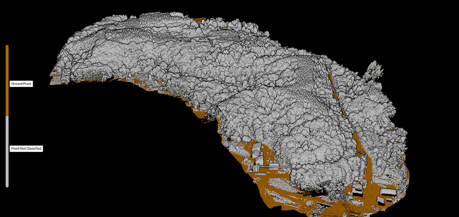
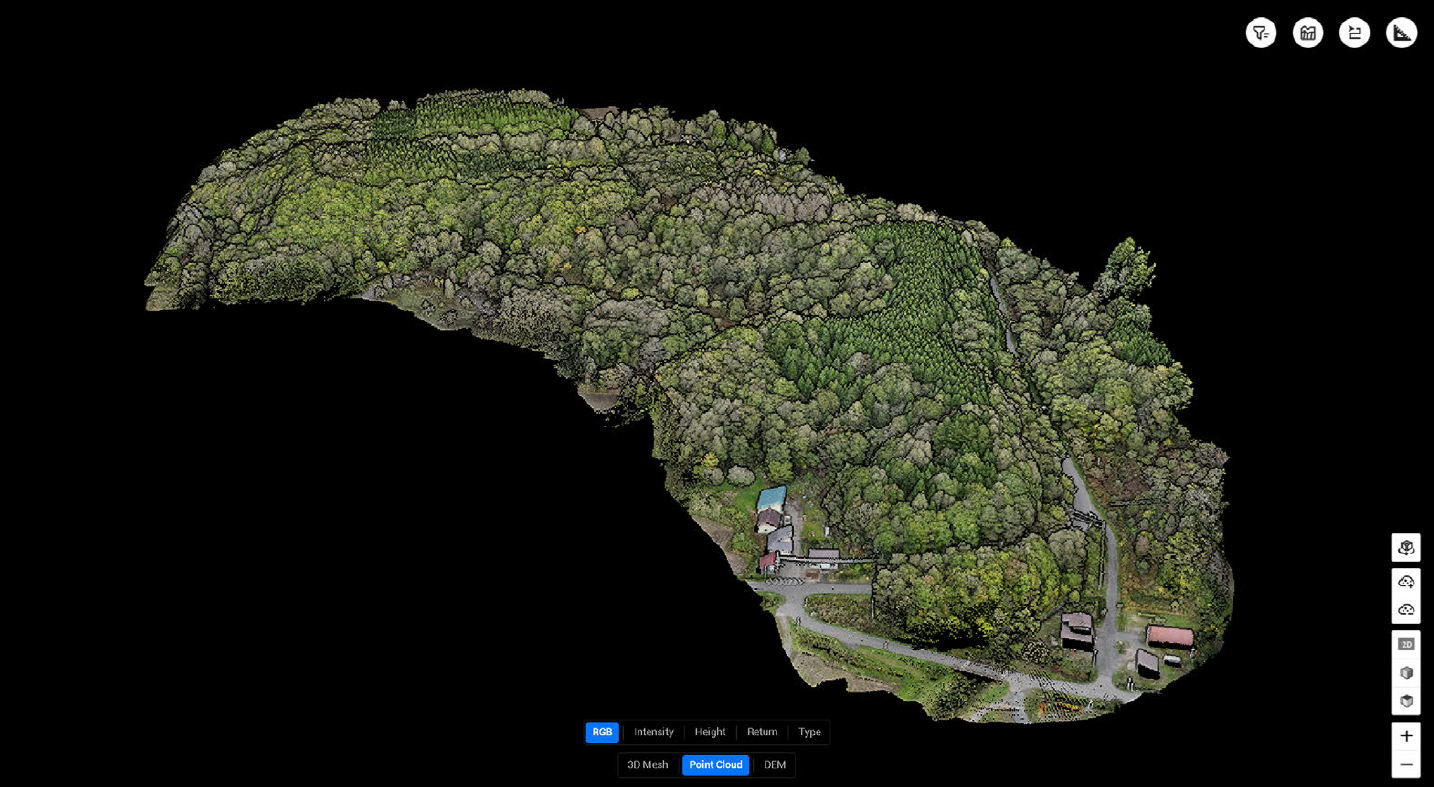
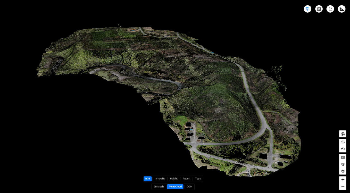
DENSE POINT CLOUD
LiDAR Dense Point Cloud is a high-resolution 3D digital representation composed of millions to billions of spatially referenced points captured by LiDAR sensors.
Dense Point Clouds have become an indispensable tool in architecture, providing precise, high-resolution 3D representations of existing structures and sites that greatly improve design, conservation and documentation workflows.
Additionally, advanced processing—such as segmentation, semantic classification and integration with photogrammetry—enhances visualisation, analysis and data interoperability across CAD and BIM platforms, supporting better-informed decisions throughout a project’s lifecycle.
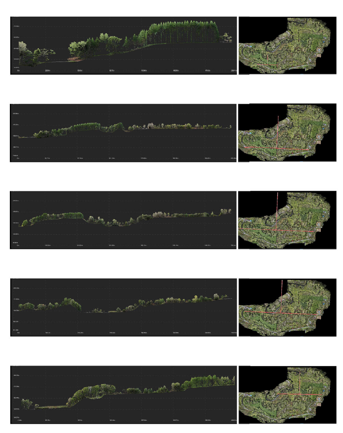
LATERAL SECTIONS
Lateral Section Analysis derived from LiDAR scans provides precise cross-sectional profiles of terrain and built features, enabling accurate measurement of slopes, cut-and-fill volumes, and sub-surface object extents across project corridors.
By extracting consistent, high-density lateral sections at defined intervals, engineers and planners can assess subtle changes in elevation, identify drainage paths, detect encroachments or obstructions, and validate design assumptions against as-built conditions.
This detailed section data streamlines earthworks estimation, risk assessment for slope stability, and alignment optimisation while reducing site visits and allowing rapid iteration of design scenarios. Integrating lateral section outputs with CAD and BIM workflows ensures coherent documentation and supports informed decision-making throughout project development.
3D SUNPATH SIMULATION
A 3D Sunpath Simulation provides architects with a precise, dynamic visualisation of solar movement around a site, enabling informed decisions on orientation, fenestration, shading devices and material selection to maximise natural light while minimising glare and overheating.
By modelling seasonal and hourly sun angles, local topography and surrounding obstructions, the tool predicts daylight penetration and solar heat gain for both residential and commercial buildings, supporting compliance with daylighting standards, improving occupant comfort and reducing reliance on artificial lighting and mechanical cooling, ultimately leading to more sustainable, cost-effective designs.
All this and a full set of high resolution, plus raw files in your password protected
client portal page.
A dedicated project webpage provides a single, easy-to-share link for your team, summarising key documents, progress updates and contact details in a compact, organised layout.
Access is secured by password protection so only authorised members can view sensitive information, and permissions can be updated centrally to reflect role changes or new collaborators.
project
MAKKARI 181
cost estimation preview

On assessed area 45,000 sqM.
Lite Package
JPY 1,485,000
10% tax includedFull PRO Package
3D Mapping Modeling up of 45k sqM.
JPY 3,190,000
BEST VALUE10% tax included*click here to download the official proposal contract.